Wednesday, October 8, 2014 - Blog on a Log
Wild Trip Reports: Hiking Bear Lake Trail
At Wilderness Supply we encourage our staff to get out and use our gear as much as they can - it's the best way to make sure they know what to recommend to you! Our employees can be found adventuring all over the world, but today we bring you a Wild Trip Report from close to home: the Bear Lake Trail in Manitoba.
These posts will be a chance to feature some of our staff's adventures (and misadventures, no doubt!) wherever they may lead. Whether on the road, trail, or water, we love sharing our experiences with you, and hope you'll be able to use them for your own inspiration and planning...or perhaps just a little vicarious living!
Bear Lake Trail
Tripper: Heather
Location: Bear Lake Trail, Manitoba
Type: Hike
Date: September 21, 2014
View Route Map
*Maps represent a guideline only - actual distance will vary due to path variations and conditions, and a full topographical map is always recommended.
My partner is the more experienced hiker of the two of us. Most of my back country experience is multi-day canoe trips, with only a few long distance hikes under my belt so we decided to hike this particular trail because it is so “close” to the Mantario Trail, and would give me an idea of what the terrain will be like when we finally get around to hiking that. I've canoed that route multiple times, but have yet to hike it, and will admit to being a little nervous about giving it a go.
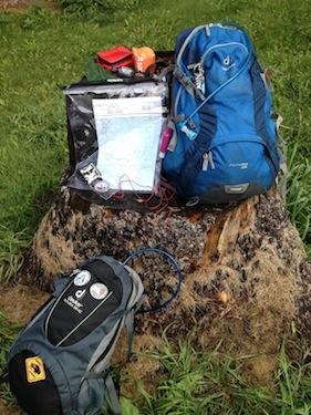
The Bear Lake Trail is approximately a two and a half hour drive from Winnipeg. There is a small parking lot off of the picnic area with an outhouse, a garbage cage and the trail sign. I was surprised at how many small flies and gnats were still around this late in the summer, but nothing was biting. Craig had thought to bring his bug net hat, so he wasn't bothered by the bugs while we took a few minutes to double check our gear. We both use a 28L day pack with a 3L hydration pack, which is on the larger size for such a short hike, but I like having the extra space to bring some emergency gear and like knowing we have more than enough clean water. Not that we expect anything to go wrong, but between the two of us, we always have a small first aid kit, an emergency bivy each, some waterproof matches, a compass and map, trail mix, and an extra pair of socks and shirt just in case.
Bug net hats - a backcountry luxury!
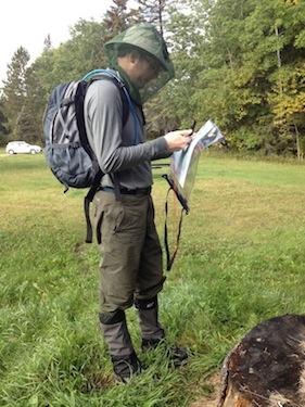
We had just recently taken the Orienteering course through Wilderness Supply as a refresher from our days in Girl Guides and Scouts, and decided this would be a good time to practice our navigation skills. Once Craig had taken our bearing, we started out on the trail, and soon discovered the source of the wonderful company buzzing our heads. There is a walkway going through the swamp, but it has clearly been a long time since any maintenance was done and you have to step carefully. It had rained early that morning, making the boards very slippery, and the tall marsh grass makes it difficult to see where there missing planks are.
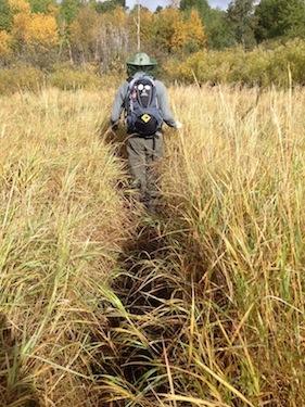
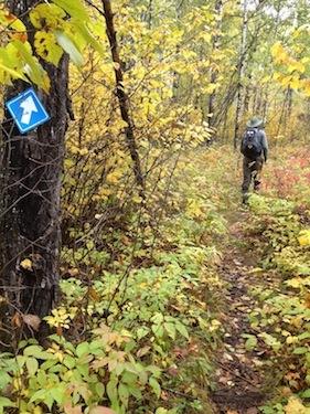
Once you get past the swamp, the trail becomes a very nice walk through the woods. The leaves were still very wet from the rain and since Craig was in front, his hiking pants got very wet, very fast, and made both of us glad we had worn our gaiters. After about a half hour of walking through the woods, it starts to become the typical rocky Canadian Shield terrain, also very slippery from the recent rain fall.
The trail becomes less well marked the further in you go, which made us very happy we had a bearing to consult while we searched for the trail markers. At some point other hikers had used flagging tape along the way, but most of it is faded and brittle from UV damage, so you can't rely on that. The trail markers also change from blue to yellow signs at random intervals, which made us a little nervous at first that maybe we got on a different trail that wasn't on the map, but we just kept consulting the compass and the map and eventually made it to the lake.
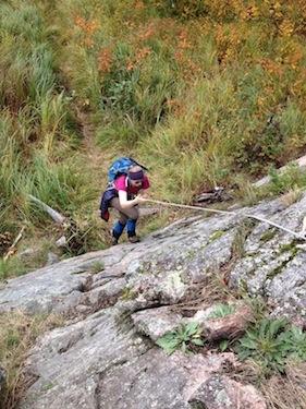
There is steep rocky hill you have to climb down to get to the lake, and then another one if you want to get to the fire place on the point of the peninsula. Some wonderful hiker had left a rope to help you get up and down that second rocky hill, as it is nearly vertical. The rope is definitely damaged from being exposed for a long time and Craig cut his hand up a bit using it, but other than that it was a pretty exciting climb.
After cleaning up and bandaging Craig hand, we enjoyed a snack and the view, and then started back. The down slopes on the hike back were more difficult for me to handle. Years of sports injuries and getting hit by a car as a pedestrian has left me with a weaker left leg. For that reason I know that my ankle can't handle hiking in anything less than a full boot. And even though the sun had finally come out and was drying things up nicely, the rocks on the down slopes were often shaded and were still very slippery. I landed wrong a few times coming down. Thankfully I only turned my ankle a few times, but each time was worse than the last, and I was limping by the time we got back to the boardwalk.
We had also found that the trail markers were more difficult to spot on the way back because most of them face the other way. Thanks to the orienteering course, we had the idea to take a back baring before leaving the lake and that helped us find the proper trail the few times we got turned around since everything pretty much looks the same out here on the prairies.
Overall it is a lovely hike. It gets more challenging the closer you get to the lake, but the view is worth the effort, and if you think you aren't up to hiking the Mantario, this trail is a good alternative. We have already decided we'd like to come back and try snow-shoeing it in winter.
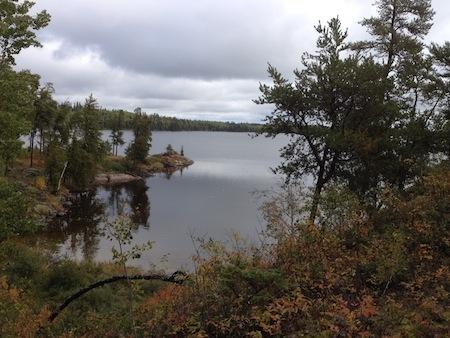
Made it to the lake!
Trip Length: 6 kilometers return (2 hours)
How to get there: Trailhead is found on Highway 44, approximately 13 km east of Rennie.
Gear List
On My Feet
- SmartWool Mid Weight Hikers

- Vasque Breeze GTX hiking boots
On My Back
- Quick Dry Hiking pants
- SmartWool PHD Run tshirt
- TNF Thermoball mid layer
- Merino Buff
In My Bag
- Deuter Futura Pro
- Topo map in Map Case
- Suunto Compass
- Platypus Big Zip 3.0L
- Water Purification Tablets
- Headlamp
- First Aid Kit
- SOL Bivy Bag
- Stormproof Matches
- Home-made Trail Mix
- Spare SmartWool Socks
- Spare quick dry tshirt - TNF Voltage Tee
- Rain Jacket and Pants