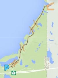
Hunt Lake Trail and Map Guide
All trip information is accurate to our knowledge at the time of posting, and provided for informational purposes only. Map additions or suggestions can be directed to info@wildernesssupply.ca. All images and descriptions are the property of Wilderness Supply.
Trip Details
Type: Hiking or Snowshoeing
Approximate Distance: 12.6 km return
Recommended Time: 3-5 hrs hiking / 4.5-6 hrs snowshoeing (depending on conditions)
Fees/Permits required: The trail is located in Whiteshell Provincial Park, so a Manitoba Parks vehicle pass is required.
Click through for full interactive google map
Planning
The Hunt Lake trail is an out-and-back trip. The trail is fairly steep in places and moves over rocky, rough terrain. Hiking poles are a good idea to provide yourself with extra stability. Ensure that you have proper footwear that offer good stability for this rough granite trail with has lots of ups and downs.
Hunt Lake is within the Whiteshell Provincial Park, so be sure to bring a parks pass for your vehicle. Cell reception can be patchy in this area, and we suggest taking a SPOT unit (which is available for rent) in case of an injury or emergency.
Getting There
From Winnipeg travel east on the TransCanada Highway towards Ontario. Take the West Hawk Lake turnoff and turn right at the stop sign when you reach Highway 44. Continue until you see the trailhead sign.
The Route
Originally Hunt Lake trail was a loop that continued and turned south into Ontario before returning to the trailhead. Now the trail is a simple out-and back, well marked and quite easy to follow.
The fist section of the trail passes through cedar groves beside Hunt Lake. Once you turn north the remainder of the trail follows the shoreline of West Hark Lake, ascending up a high ridge which drops off via sharp cliff faces into West Hawk Lake. A shelter marks the end of the official trail at Little Indian Bay.
Important Notes:
- Always leave a detailed trip plan and estimated time of return with someone at home before embarking on any trip.
- Hunt Lake trail is accessible in the winter, but remember to take snow shoes as the westerly winds off West Hawk Lake tend to drift deep snow onto the trail. Once West Hawk freezes solid it can be used for the the return portion of the journey. However, ensure that you have confirmed the ice thickness as West Hawk being Manitoba's deepest lake can take a little bit longer than other area lakes to freeze.
- Bring a full topographical map and compass even if you have a GPS, and make sure that someone in your group is familiar with how to read them.
- If you have questions about this or any other trips, please visit your nearest Wilderness Supply store, where our staff will be happy to provide advice and suggestions!

