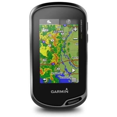
Garmin Oregon 700 GPS Device
This product is no longer avaliable.
Thanks to a redesigned antenna for better satellite reception, the Oregon 700 GPS and GLONASS handheld puts even more of the great outdoors at your fingertips. Whether you’re hiking, hunting, climbing, kayaking, trail riding or whatever, this rugged navigator is ready for anything. It features multilink wireless connectivity (Wi-Fi, Bluetooth and ANT+), Active Weather support with animated radar overlays, a 1-year BirdsEye Satellite Imagery subscription and a built-in 3-axis compass with barometric altimeter.
Features:
- High-sensitivity dual GPS and GLONASS satellite reception for better performance in challenging environments than GPS alone
- Redesigned antenna enables better reception and performance; 3-axis compass with accelerometer and barometric altimeter sensors
- 3-inch sunlight-readable touchscreen with dual orientation (landscape or portrait view)
- Expanded wireless connectivity (Wi-Fi, Bluetooth®, ANT+® capable); supports Active Weather and Geocaching Live
- Bluetooth®-enabled smart notifications¹ and automatic uploads to Garmin Connect™ online community
- Includes: Oregon 700, USB cable, Carabiner clip, Documentation
Specifications:
General:
- PHYSICAL DIMENSIONS 2.4" x 4.5" x 1.3" (6.1 x 11.4 x 3.3 cm)
- TOUCHSCREEN
- DISPLAY SIZE 1.5"W x 2.5"H (3.8 x 6.3 cm); 3" diag (7.6 cm)
- DISPLAY RESOLUTION 240 x 400 pixels
- DISPLAY TYPE transflective color TFT touchscreen
- WEIGHT 7.4 oz (209.8 g) with batteries
- BATTERY TYPE 2 AA batteries (not included); NiMH or Lithium recommended, rechargeable NiMH pack (optional)
- BATTERY LIFE up to 16 hours
- WATER RATING IPX7
- HIGH-SENSITIVITY RECEIVER: Yes
- INTERFACE high speed mini USB and NMEA 0183 compatible
- MEMORY/HISTORY 3.4 GB
Maps & Memory:
- ABILITY TO ADD MAPS: Yes
- BASEMAP: Yes
- AUTOMATIC ROUTING (TURN BY TURN ROUTING ON ROADS) FOR OUTDOOR ACTIVITIES Yes (with optional mapping for detailed roads)
- MAP SEGMENTS 15000
- BIRDSEYE 250 BirdsEye Imagery files
- INCLUDES DETAILED HYDROGRAPHIC FEATURES (COASTLINES, LAKE/RIVER SHORELINES, WETLANDS AND PERENNIAL AND SEASONAL STREAMS) no (additional mapping needed)
- INCLUDES SEARCHABLE POINTS OF INTERESTS (PARKS, CAMPGROUNDS, SCENIC LOOKOUTS AND PICNIC SITES) no (additional mapping needed)
- DISPLAYS NATIONAL, STATE AND LOCAL PARKS, FORESTS, AND WILDERNESS AREAS no (additional mapping needed)
- EXTERNAL MEMORY STORAGE yes (32 GB max microSD™ card)
- WAYPOINTS/FAVORITES/LOCATIONS 10000
- TRACKS 250
- TRACK LOG 20000 points, 250 saved tracks
- ROUTES 250, 250 points per route; 50 points auto routing
Sensors:
- GPS: Yes
- GLONASS: Yes
- BAROMETRIC ALTIMETER: Yes
- COMPASS: Yes (tilt-compensated 3-axis)
- GPS COMPASS (WHILE MOVING): Yes
Daily Smart Features:
- GPS
- GLONASS: Yes
- BAROMETRIC ALTIMETER: Yes
- COMPASS Yes (tilt-compensated 3-axis): Yes
- GPS COMPASS (WHILE MOVING): Yes
Outdoor Recreation:
- POINT-TO-POINT NAVIGATION: Yes
- COMPATIBLE WITH BASECAMP: Yes
- AREA CALCULATION: Yes
- HUNT/FISH CALENDAR: Yes
- SUN AND MOON INFORMATION: Yes
- XERO™ LOCATIONS: Yes
- GEOCACHING-FRIENDLY: Yes (Geocache Live)
- CUSTOM MAPS COMPATIBLE: Yes (500 custom map tiles)
- PICTURE VIEWER: Yes
Connections
- WIRELESS CONNECTIVITY: Yes (Wi-Fi®, BLUETOOTH®, ANT+®)


